The SSSS - early musings - 2013>2015

If NASA faked the moon landings, does the agency have any credibility at all? Was the Space Shuttle program also a hoax? Is the International Space Station another one? Do not dismiss these hypotheses offhand. Check out our wider NASA research and make up your own mind about it all.
agraposo
Member
Posts: 267
Joined: Fri Jun 10, 2011 9:48 pm

Re: The SSSS

Unread post by agraposo »

I have understood that Simon has taken away the small Earth's orbit (around what?, as I asked in a previous post) from his model, by simply putting the equatorial plane in the horizontal plane, instead of the ecliptic plane. But that's a simple change of perspective!

Image

horizontal equatorial plane
Image

horizontal ecliptic plane
Image

And I don't understand how this explains the rate change in declination in the analemma that Simon was asking:
simonshack wrote:The (in)famous 23.5° "axial tilt of the Earth" is nothing but the Sun's orbital inclination to the Earth itself. It adds up to a 47° shift of the Sun's position in our skies - between June and December. This also goes to explain, for instance, why we see the Sun declining most dramatically between August and October - along with all the planets on its own ecliptic plane: Mercury, Venus - AND the Moon!
I will give an explanation of how the declinaton rate behaves in the analemma later.
Last edited by agraposo on Wed Aug 14, 2013 5:39 pm, edited 3 times in total.
lux
Member
Posts: 1911
Joined: Sat Oct 01, 2011 10:46 pm

Re: The SSSS

Unread post by lux »

OK, so the Earth is not moving in a small, circular path then.
agraposo
Member
Posts: 267
Joined: Fri Jun 10, 2011 9:48 pm

Re: The SSSS

Unread post by agraposo »

In this diagram I posted I see now more clearly why near the solstices the declination changes less rapidly than near the equinoxes.
Image

The movement of the Sun in the ecliptic has two components: north-south (declination) and east-west (right ascension). Near the solstice, the movement is more east-west that north-south, in the solstice it is just east-west. As the Sun goes from solstice to equinox, the north-south component (declination) increases, and then decreases until the next solstice, where there is no declination change.

This diagram can help (page 15 of the pdf document). The declination change is the vertical arrow. In the solstice there is no vertical arrow, no declination change. In the equinox, the vertical arrow is bigger (there is more change in the declination).

Image
http://www.math.nus.edu.sg/aslaksen/projects/tsy.pdf

By the way, Simon, in your diagram should "Earth's ecliptic plane" read "Earth's equatorial plane" instead?
simonshack
Administrator
Posts: 7345
Joined: Sun Oct 18, 2009 8:09 pm
Location: italy
Contact:

Re: The SSSS

Unread post by simonshack »

*

THE TRUE MEANING OF DECLINATION

This is all turning out to be charmingly logical and I, for one, am satisfied to have cleared up for myself how our 'solar system' is configured. The vexing question of why we see our surrounding celestial bodies, the Sun, the Moon, Mercury and Venus (let's leave Mars and the other planets for a later time) steeply rise and descend around the equinoxes - ALL on (almost) the same plane - has now finally a perfectly logical answer!

Given due time and patience, everyone can verify for him/herself that the "Sun-Moon-Planets ballet" that we see in our skies plays out as described above, with all those celestial bodies (seemingly aligned on their own plane) rising and descending between the two solstices of June and December. At the solstices, their common, oblique plane flattens out and reverses from / to \ ... Why?

Why, for instance, can we see them all lined up on this oblique path - as shown on this screenshot (depicting the positions of these celestial bodies on August 12, 2013) that I took of the lovely NEAVE INTERACTIVE PLANETARIUM ?

Image

Here is why - in my opinion - this happens. Please note that, to make my following point (and graphic), I have simply taken the declination values as given in the above NEAVE screenshot - and integrated them into the SSSS model :

Image
(I know, my graphic isn't geometrically perfect / proportionate. This is just to give an idea of this particular issue.)

I believe that this demonstration effectively rules out the Copernican model - which certainly does NOT account for (and cannot geometrically / empirically explain or justify) the way that we ACTUALLY see the Sun, the Moon and our planets moving around the skies - steeply ascending and descending around the time period of the equinoxes (March and September). In absence of any better explanation for these planetary motions that we can observe with our own eyes, I will say that my Tycho Brahe-inspired "SSSS" is the most plausible model of our "solar system" available today.
simonshack
Administrator
Posts: 7345
Joined: Sun Oct 18, 2009 8:09 pm
Location: italy
Contact:

Re: The SSSS

Unread post by simonshack »

agraposo wrote:
By the way, Simon, in your diagram should "Earth's ecliptic plane" read "Earth's equatorial plane" instead?
Dear Agraposo,

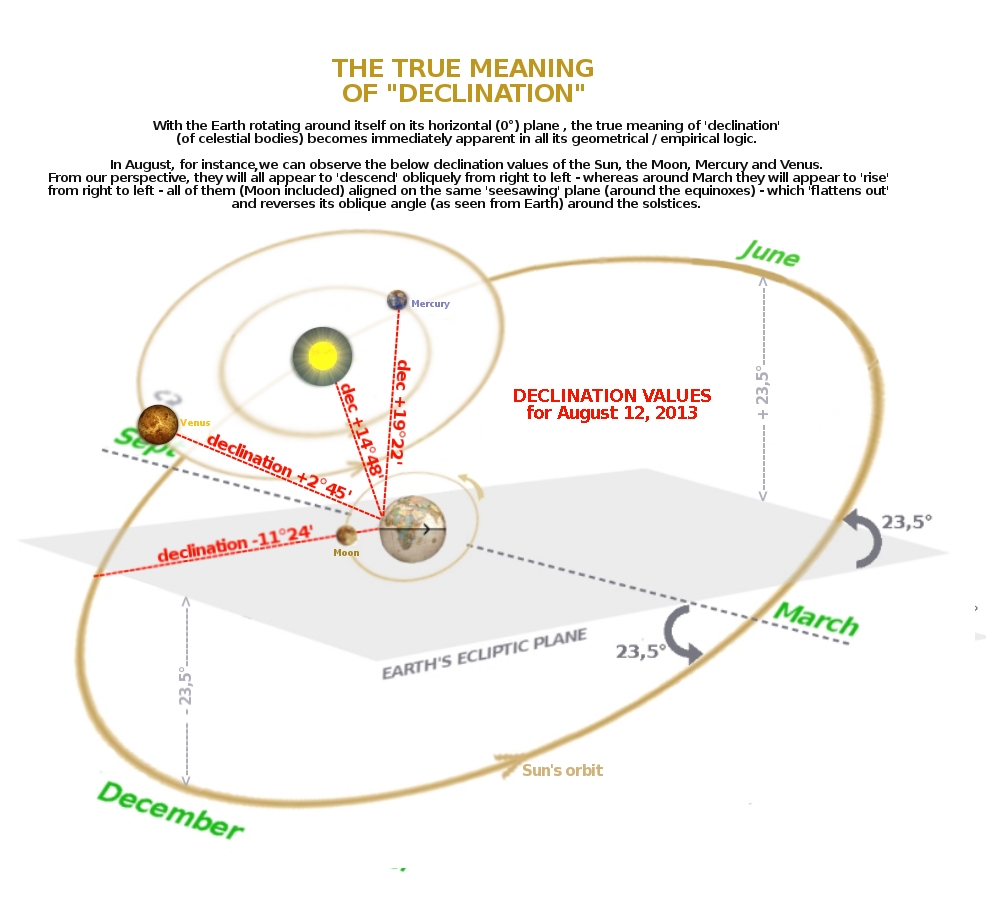
I chose to name it the "ecliptic plane" rather than the "equatorial plane" for a reason. In the Copernican model, the "equatorial plane" actually tilts (from our earthly perspective) by 23,5° one way and 23,5° the other (between the solstices). In my model, the equatorial plane is nothing but the Earth's ecliptic - stable throughout the years at 0°. To be sure, it is not a simple change in perspective from the Copernican model. The Earth is not the tilted object. What tilts back and forth (from our earthly perspective) is most obviously the (nearly) common / identical orbital plane of ALL of our surrounding celestial bodies (the Sun, the Moon, Mercury, Venus, etc). The Copernican contention that the EARTH is tilted by 23,5° simply does not add up with the trajectories of these celestial bodies which we can observe from Earth.

Now, if you are under the common assumption that the Equator is a line over which the Sun always passes straight overhead, think again - as this is just a popular myth.

To see this with your own eyes, let me guide you to how the NEAVE INTERACTIVE PLANETARIUM will show you this fact:

1: Go to the NEAVE site and choose any location on the equator by clicking on the location button: Image

2: Choose a NOON timeline of any day you wish - and rotate the sky (by clicking and dragging) to find the Sun .

3: Position yourself first (and this is very important) as if you were looking SOUTH.

4: Now, start toggling (by clicking and holding) the month-to-month function. You will see the Sun performing the "analemma" - drifting up and down on your screen, with the Sun declinations going from +23,5° (June) to -23,5°(December).

5: Next, position yourself as if you were looking EAST - and toggle the month-to-month button. You will now see the "analemma" drifting 'horizontally' - from the left to the right of your screen! Why would that be?


Well, if you spend some time trying to visualize all this as if you were really standing at the Equator - and assuming that my SSSS model is correct, you should be able to see that it IS, in fact, correct.

I know, in order to process this in your mind, you will have to appeal to your very best senses for spatial perspective. It's hard work indeed! Yet, once you 'get it', it should all become quite obvious to you. And no, these observations can NOT be made (and will NOT be equivalent) under the frame of reference and planetary motions as proposed by the Copernican model.


lux wrote:OK, so the Earth is not moving in a small, circular path then.
Dear Lux,

I have tried to explain (probably poorly so) why my initial premise of the SSSS included this small orbit of the Earth in front of the Sun. It was a mistake which I proudly admit - as I believe it was an important and necessary 'step' to take (for my mind as well as yours - and anyone else's) to overcome the aberrations of the Copernican model. If you will, we could call this a 'reverse-engineering' of sorts, where gradual steps/ phases are needed in order to break down common, die-hard assumptions / dogmas related to our solar system's configuration (as 'definitively established', for some unfathomable reason, by Copernicus and a few other folks 400 years ago). At the time, there was a RAGING debate as to Tycho Brahe's geo-heliocentric model and the new, Keplerian and Copernican models. Galileo himself was evidently confused and didn't even know which side to take - as his writings betray. All in all, there is absolutely NOTHING STRANGE in arguing that the Sun orbits the Earth - and not vice versa. I now believe to have presented strong evidence to back up this claim - and anyone is free to evaluate its validity.
simonshack
Administrator
Posts: 7345
Joined: Sun Oct 18, 2009 8:09 pm
Location: italy
Contact:

Re: The SSSS

Unread post by simonshack »

*

365 SUNRISES versus 366 STAR RISES

If you have ever asked yourself why we see the Sun rising 365 time a year - whereas we see the starfield 366 times a year, here is the logical explanation - as of my SSSS model, with the Sun revolving around Earth. I have chosen AQUARIUS as a star reference which we actually see 366 times each year - whereas we see the Sun once less, i.e. only 365 times a year. Please imagine the Earth's daily rotation (in my below gif animation) as sweeping 180° at each step - and imagine earthly observers keeping the score of every sighting of Aquarius and the Sun :

Image
lux
Member
Posts: 1911
Joined: Sat Oct 01, 2011 10:46 pm

Re: The SSSS

Unread post by lux »

Thanks for the clarification, Simon.
simonshack
Administrator
Posts: 7345
Joined: Sun Oct 18, 2009 8:09 pm
Location: italy
Contact:

Re: The SSSS

Unread post by simonshack »

*

THE "POLE" QUESTION


A classic diagram of the Copernican model:
Image

The Copernican model illlustrates our Earth revolving around the Sun, tilted at a 23,5° angle. Fine. But how does this explain the fact that the tips of the North and South Poles experience almost half-a-year of darkness? In fact, this is a little-known fact : people usually talk about the wondrous "midnight sun", which can be seen in the summer in places like northern Norway - yet still a bit away from the actual North Pole. Well, let's talk about winter up there (or down at the South Pole). Did you know that the extremities of our planet, the poles, do not see the sun rising for about 160 / 170 days out of our 365 solar days? If you knew that already, have you ever asked yourself WHY this would be the case - under the assumption that the Copernican solar system would be perfectly true and valid? Why would the two poles dip into complete darkness at such early points (late March / late September) of Earth's alleged 360° orbit around the Sun?

Image


Well, if you just take a good look at my SSSS model, you will readily see exactly why this happens. I have not drawn any of the Sun's motions into this graphic - I will just let your own brains visualize the yearly motion of the Sun - according to this model:

Image

In the SSSS, the angle at which the Sun orbits around the Earth would clearly obscure the two poles soon after the Sun's passage of the equinoxes. Also, please note that the Earth is slightly off-center (of the Sun's orbit) in my model. This goes to explain why the North Pole experiences about three more weeks of sunlight than the South Pole. In any case, the most compelling evidence supporting the SSSS model is, as previously stated, the fact that our closest surrounding celestial bodies (Sun, Moon, Mercury, Venus) all appear to be moving in oblique lines (RISING AND DESCENDING) on pretty much the very same plane. The Copernican model simply cannot account for this - and has to be discarded once and for all. It is an embarrassing theory (still taught in schools) which makes all of us earthlings look stoopid.

And to those who think that my SSSS is simply a (totally equivalent) reverse-view of the officially established Copernican concept with Earth tilted at 23,5°, please understand that this just isn't the case. The empirical observations of our skies do NOT add up with the Copernican model. Instead, they accurately support the SSSS model - from every perspective that I can think of. Am I wrong? Only time will tell.
hoi.polloi
Member
Posts: 5060
Joined: Sun Nov 14, 2010 7:24 pm

Re: The SSSS

Unread post by hoi.polloi »

simonshack wrote:The Copernican model illlustrates our Earth revolving around the Sun, tilted at a 23,5° angle. Fine. But how does this explain the fact that the tips of the North and South Poles experience almost half-a-year of darkness? In fact, this is a little-known fact : people usually talk about the wondrous "midnight sun", which can be seen in the summer in places like northern Norway - yet still a bit away from the actual North Pole. Well, let's talk about winter up there (or down at the South Pole). Did you know that the extremities of our planet, the poles, do not see the sun rising for about 160 / 170 days out of our 365 solar days? If you knew that already, have you ever asked yourself WHY this would be the case - under the assumption that the Copernican solar system would be perfectly true and valid? Why would the two poles dip into complete darkness at such early points (late March / late September) of Earth's alleged 360° orbit around the Sun?
I think I see what you are alleging, Simon.
model_hp11.GIF
model_hp11.GIF (8.52 KiB) Viewed 14943 times
Are the North and South poles hidden in flattened pits surrounded by high mountains which shield them from the rays of the Sun for a week or more? The poles never appear that way in photos allegedly taken there. (Though the mystery of the poles and why so few have allegedly visited them is a topic for another thread entirely.)
hoi.polloi
Member
Posts: 5060
Joined: Sun Nov 14, 2010 7:24 pm

Re: The SSSS

Unread post by hoi.polloi »

What is the real size of the Sun? (A gargantuan puzzle? Or merely an enormous one?)

The Sun is not just a point in the sky but an entirely apparent circle. Our first clue, its size relative to the size of its entire path in the visible sky, should be calculable. How many Sun-widths does the Sun travel on its sidereal path, per diam, over the course of the year? A relatively easy 3D geometric puzzle that could give us a better basis for determining the real size and distance of the Sun. (This clue addressed at end of post.)

The difference between a large and small Sun is somewhat important, if incalculable for the time being. For as the Sun passes the Earth, if it were a giant wall of flame, parallel light waves would blanket more of the Earth, creating a more perfect uniform intensity on the lit hemisphere. A smaller source, I mean if the Sun were actually smaller than the Earth, would cause a more focused 'spotlight' point considering we'd be getting more oblique and fewer direct waves.

Perhaps a combination of calculating the Sun's daily sidereal distance it covers (relative to its own size) and comparing various points on the Earth where the Sun's light's power has been measured can give us hints as to how big a sphere is "beaming down" upon the Earth's surface.
model_hp12.GIF
model_hp12.GIF (4.12 KiB) Viewed 14931 times
In partial estimation of the first clue, we have about 6 "days" passing before the Sun advances 4 times its width in the sidereal sky, according to the Neave site, meaning the Sun goes 2/3 of its width each day. To test this estimation further, I started the Sun in Sagittarius on January 1, 2014 (at about 00:01) and advanced two months, which should have given the Sun about 40 Suns' distance based on my crude measurement of 20 pixels for the Sun in Neave's chart. It gave me about 32, which would mean the night sky is about 192 Sun-widths around, which puts the size of the Sun in the sky at about 0.5333 degrees. Surprisingly, my very crude estimation (thanks to Neave) lined up well with the actual repeated measurements recorded on astronomy sites.

See, this somewhat matches the estimation that the Sun (and the Moon by coincidence) are approximately this many degrees wide, or averaging in the approximate range of 32 arcminutes. (The Moon fluctuates more but averages about 31 or 32.)

http://en.wikipedia.org/wiki/Angular_diameter

They claim from bouncing radar off of planets, they have determined the rest. If you've been following this thread and you have sussed it out and decided NASA is successfully shooting radar into outer space and retrieving signals back, I'm not saying it's impossible, but I'd like an explanation please.
pov603
Member
Posts: 869
Joined: Thu Jun 30, 2011 8:02 pm

Re: The SSSS

Unread post by pov603 »

simonshack wrote:*

Well, if you just take a good look at my SSSS model, you will readily see exactly why this happens. I have not drawn any of the Sun's motions into this graphic - I will just let your own brains visualize the yearly motion of the Sun - according to this model:

Image


And to those who think that my SSSS is simply a (totally equivalent) reverse-view of the officially established Copernican concept with Earth tilted at 23,5°, please understand that this just isn't the case. The empirical observations of our skies do NOT add up with the Copernican model. Instead, they accurately support the SSSS model - from every perspective that I can think of. Am I wrong? Only time will tell.
In regard to the above observation, the ecliptic plane could explain what the 'tropics' are all about especially as they lie at or near to the 23.5 deg line.

http://en.wikipedia.org/wiki/Circle_of_latitude

Presumably the Sun would be at the closest to the Earth on a line bounded by the Tropics of Cancer/Capricorn. One could then presume that the hottest temperatures would be plotted on or near to this rather than always along latitude 0 deg.

If so, this could explain the reasons behind the following:
http://hypertextbook.com/facts/2000/MichaelLevin.shtml
Hottest temperature in South America recorded at Rivadavia. 24 deg S [not to be confused with Comodoro Rivadavia further south].
http://www.collinsmaps.com/maps/Argenti ... 04.00.aspx
Hottest temperature in North America [discounting the Death Valley one which is apparently suspect]: Sonoran Desert which starts at Latitude 25 deg N.
Middle East: no data yet to post a link to but I can add that it is commonly known Kuwait [which is north of where i am in Dubai], is always the hottest place amongst the Middle Eastern cities/states during the Summer months and it lies at Latitude 29 deg N.
simonshack
Administrator
Posts: 7345
Joined: Sun Oct 18, 2009 8:09 pm
Location: italy
Contact:

Re: The SSSS

Unread post by simonshack »

hoi.polloi wrote:What is the real size of the Sun? (A gargantuan puzzle? Or merely an enormous one?)
Hoi,

I'm glad you brought up the puzzle of the size of the Sun. Intuitively, I would say that it is not as big as advertised ("109Xthe size of Earth"). As for the interstellar/planetary distances, that topic appears to have spawned another cosmic mess of human-produced "conjecture-literature" - as no one can rationally demonstrate that the currently accepted, untouchable 'scientific' figures MUST be correct. Perhaps at least the Moon's measurements (diameter, distance from Earth, etc...) are valid. I believe they could be - as back in the days, even Aristarchus of Samos wasn't far off the modern figures of the Moon dimensions/distances - he got Moon's diameter and distance pretty much right (as considered today).

But hey, Aristarchus had the Sun-Earth distance at only 2,4million km: that is 62 times less than the modern figure of 150million km! In fact, the modern available figures are something that even the top science-hubs cannot claim as demonstrable, incontrovertible facts. Perhaps the question of the Sun's dimension and distance from the Earth will have to wait a little - until the world's scientific community can legitimally claim to have wrapped their heads around it: I doubt this will happen soon. Besides, how can WE mere citizens pretend to know better? Can YOU calculate how far the Sun is from Earth at any time of day? It's not like it is an easy matter to figure out (notwithstanding our modern technology)for ALL of us earthbound human beings - however scientifically-inclined.
Heiwa
Banned
Posts: 1062
Joined: Tue Oct 20, 2009 6:20 pm
Contact:

Re: The SSSS

Unread post by Heiwa »

simonshack wrote:Can YOU calculate how far the Sun is from Earth? It's not like it is an easy matter to figure out (notwithstanding our modern technology)- for ALL of us earthbound human beings - however scientifically-inclined.
Archimedes, my favorite Greek that explained 200 BC why ships float, also thought, based on observations (his father was an astronomer), that Earth was the center of our Solar system and that the Moon, the Sun and the then five known planets Mercury, Venus, Mars, Jupiter and Saturnus orbited Earth in circles in one common plane. Archimedes also, apparently, managed to calculate the distance of the Moon and the Sun from Earth but apparently the Romans destroyed the calculations or the circles when they murdered him in his office. In SSSS the planets (except Earth) orbit the Sun. Simon, why is your model different from Archimedes? Didn't you go to school where Archimedes died?
agraposo
Member
Posts: 267
Joined: Fri Jun 10, 2011 9:48 pm

Re: The SSSS

Unread post by agraposo »

simonshack wrote: Image
You can see that with the help of this simulator.
http://astro.unl.edu/naap/motion1/anima ... iptic.html

Click and drag with the mouse to obtain this position, looking to the system Sun-Earth from above. It is June 21st and all the locations above the arctic circle (the small green circle) are experiencing a sunny day during 24 hours. At this point imagine the Earth rotating around its axis (visible as a small dash).

Image

As we are approaching the autumn equinox, in the north pole is still sunny the whole day, but in other locations above the arctic circle it is night for some hours.

Image

Then, from the autumn equinox to the spring equinox, in the north pole is night the whole day. This is the diagram on November 12th.

Image

And from the spring equinox to the autumn equinox is sunny the whole day in the north pole. This is the diagram on May 12th.

Image
agraposo
Member
Posts: 267
Joined: Fri Jun 10, 2011 9:48 pm

Re: The SSSS

Unread post by agraposo »

We also can click on "celestial sphere" instead of "orbit view" and obtain the same results. This would be the geocentric view.

Image
Locked